Deserted medieval village of Santa Creu de Llagunes
Self-guide
This is the highest-altitude archaeological site discovered to date, featuring remains of human presence from prehistory, the Middle Ages, and the Spanish Civil War.
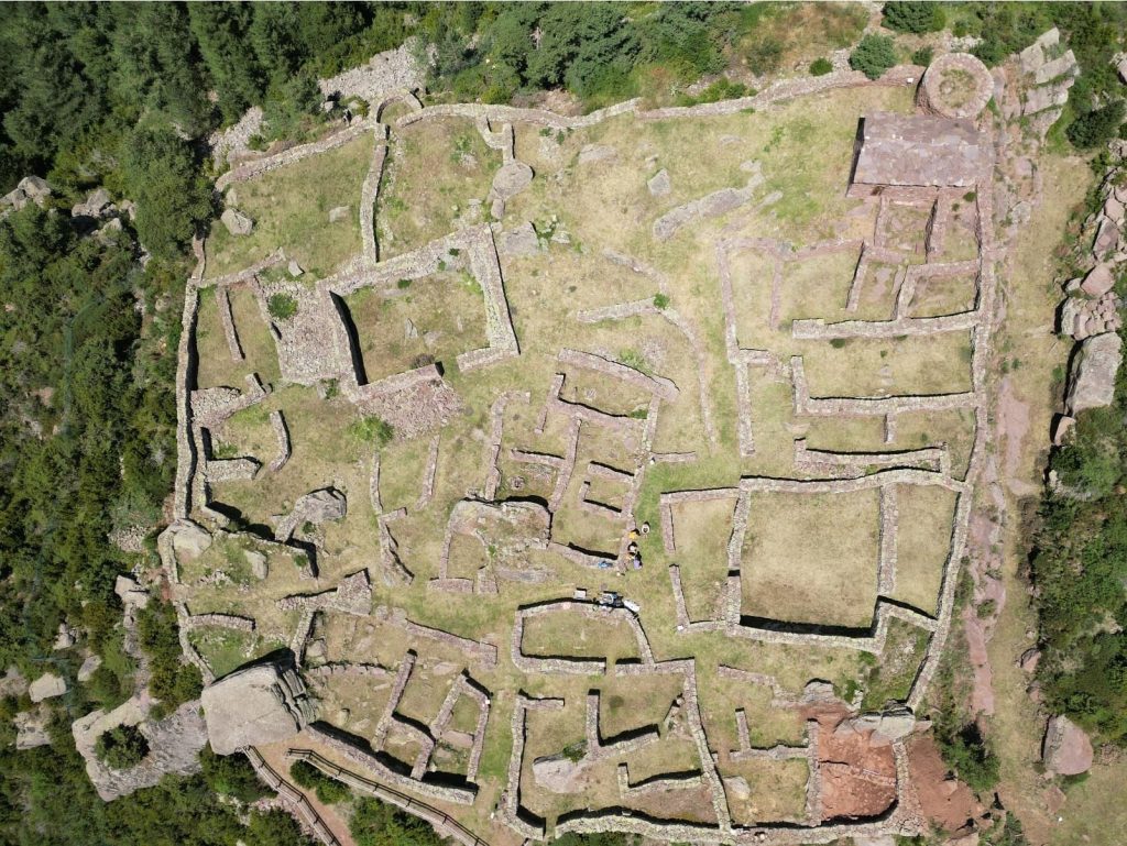
This self-guided tour will facilitate your visit and provide the necessary information to understand your surroundings, thanks to the excavations and subsequent studies by the various archaeologists and historians who have worked here. It is important to keep in mind that we possess no written documents whatsoever referencing this site.
Welcome to the archaeological site of the deserted medieval village of Santa Creu de Llagunes. This is the highest-altitude archaeological site discovered to date, featuring remains of human presence from prehistory, the Middle Ages, and the Spanish Civil War. It is a strategic vantage point offering stunning views of the Siarb Valley, Pallars Sobirà, Pallars Jussà, and even Ribagorza, which you can enjoy while discovering this place.
Instructions
The instructions are very simple: follow the route according to the map, where you will find the points marked with their corresponding numbers. While this is the most logical itinerary, you are free to explore according to your own interests, as the proposed route alternates between different historical periods.
At most points of interest, you will find an information board indicating where you are and which section of the self-guided tour to consult. At other points of interest that are more recent or newly excavated, there will be no panel, but they will be easy to identify using the map.
First, you need to scan the QR code from the brochure handed to you at the site’s information booth. Once downloaded, the tour will be available on your mobile phone; a digital PDF is also provided just in case. You will find the information in Catalan, Spanish, English, and French. Simply follow the languages down the document until you find yours.
Basic information about the site
The site’s typology is a medieval village with a defensive character . Featuring an almost rectangular layout, it is a walled village—a fortified medieval settlement where the dwellings blend into the perimeter walls, taking advantage of the elevated terrain of the rock formation.
|
Chronology |
Dimensions |
|---|---|
|
Neolithic (5600 to 2000 BC) |
Total site surface area: 4,520 m² |
|
Bronze Age (1500 to 1100 BC) |
Total site perimeter: 270 m |
|
Middle Ages (10th – 14th centuries) |
Total surface area of the village: 2,500 m² |
|
Contemporary Era (Civil War, 1938) |
Total perimeter of the village: 194 m |
The Prehistoric Settlement
During the initial excavation campaigns, the abundant presence of prehistoric material (pottery, lithic industry, and saddle querns/grinding stones) became evident, highlighted by the discovery of flint. These findings lead to the conclusion that there were either temporary or permanent prehistoric settlements here.
The Medieval Village
At an undetermined time, provisionally placed around the 10th and 11th centuries, the presence of a village occupying the entire surface of the hill (
tossal
) is detected. This allows us to clearly identify its final phase of occupation and its abandonment at the end of the 13th century. However, it is highly likely that it was used transitorily by shepherds and others in the following centuries.
The Civil War
The site was occupied as a temporary entrenchment point by Republican troops. It became a strategic position offering an unbeatable visual control of the valley and its surroundings. Some dry-stone structures were found, serving as sentry boxes or shelters, as well as machine-gun nests located at various dominant points of the hill and inside the ditches, which are currently unidentified.
The name Santa Creu de Llagunes is a designation used ex post facto (after the fact) and refers to the name of the hill (tossal) where it is located. We have no direct documentary references associated with it. The known documentary mentions that speak of the ancient Siarb Valley are the act of consecration and endowment of the Cathedral of La Seu d’Urgell from the 11th century, and the Canonical records of the same see from 1010. These refer to the parishes of Sant Sadurní in the village of Siarb, Llagunes, and Serbans in the hands of the Viscounts of Pallars—mentioning the 8 villages that make up the valley today, leaving it open to interpretation, without clear proof, that the archaeological site could have been the original Village of Siarb.
The original toponym Siarb comes from the combination of two ancient roots meaning “the path of the foxes” (or path of the plump ones/lambs). In ancient Basque, the element axari or azari referred to the fox, and bide or bi referred to the path or pass. Over the centuries and with the Latinization of the area, the name evolved phonetically until it became fixed as Siarb. This makes perfect geographical sense, as the Siarb Valley has historically been a mandatory mountain pass and was also a place where the fox fur trade was significant.
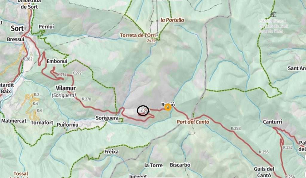
The village occupies the entire esplanade at the summit of the Tossal de la Santa Creu, at 1,628 meters above sea level, in the Siarb Valley, within the region (
comarca
) of Pallars Sobirà. This hill is located at the final section of the southern foothill of the Pic de l’Orri (2,439 m). To the south, it is bounded by the N-260 road from Sort to La Seu d’Urgell. To the west, it borders old pasture fields overlooking the bottom of the Noguera Pallaresa valley. To the north, it is bounded by an old ravine, and to the east, by an esplanade, which is the current rest area and access point. Without a doubt, it is a strategic location.
The red earth we walk on originated from the sedimentation of materials during the Permian and Triassic periods, between 299 and 201 million years ago, in a geological environment dominated by plains and numerous rivers; it owes its color to the presence of iron oxides (such as hematite). During the Permian, the initial landscape was characterized by alluvial fans and heavy torrential flooding that deposited coarse pebbles, gravel, and sand, giving rise to conglomerates and breccias. This evolved into a much calmer fluvial plain, with meandering rivers and lush forests inhabited by primitive reptiles. In the floodplains between channels, clays and silts settled, forming hardened soils during dry periods.
The transition to the Triassic is marked by a layer of clays and silts that reveals a period of great aridity with no watercourses. By the Early-Middle Triassic, in the upper part of the Siarb Valley, river activity returned. The rivers transported sand in their beds and suspended clays and silts. Often, the accumulation of sand clogged the channels, causing overflows and diverting the river’s course, leaving behind abandoned channels filled with sand as evidence.
Over millions of years, the burial of these sediments thousands of meters deep compacted them and transformed them into sandstone. Later, the Pyrenean orogeny folded and uplifted these structures, and finally, erosion caused by glaciers and rivers exposed them, shaping the current landscape of the valley.
Between the 10th and 13th centuries, the Pallars and Urgell regions underwent a profound transformation marked by violent feudalization and struggles for control over the frontier with Islam. In this context of intense militarization, the safety of the civil population became a priority, as evidenced by this fortress. We have not yet been able to identify whether there were regular troops stationed here or to whom they owed vassalage (whether to Pallars or Urgell), but it is clear that it was an important enclave for both counties. The division of the ancient county in the year 1011 between Pallars Sobirà and Pallars Jussà heightened instability. In response, the powerful County of Urgell intervened strategically by allying with Pallars Jussà.
Through campaigns led by Arnau Mir de Tost, new borders were established, leaving Jussà subordinated to the dynasties of Urgell and Barcelona. Due to political pressure and economic stranglement—and without a fight—control of Vilamur was ceded to them, a highly important bastion within Pallars Sobirà that surely caused our fortress to lose its strategic value.
Before concluding the visit, mention must be made of two climatic phenomena that occurred in the Northern Hemisphere, which particularly affected life in the deserted village and coincide chronologically with its establishment and abandonment. These are known as:
The Medieval Warm Period (c. 900–1300): Characterized by an increase in average temperatures and a stable climate, it favored agricultural expansion. The improvement in harvests allowed for considerable demographic growth and the expansion of vineyards into the high areas of the Pyrenees, such as at this site.
The Little Ice Age (c. 1300–1850): A progressive cooling caused by lower solar activity (such as the Maunder Minimum) and volcanic eruptions overturned the situation. Extremely cold winters and short, wet summers occurred, freezing rivers like the one used by the nuns of La Ribalera to wash clothes, until a novice returned to the nunnery with a piece of ice.
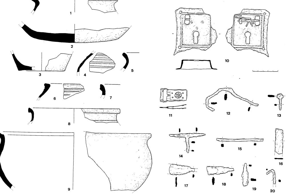
A large portion of the archaeological material from the excavations dates to the 13th century and the beginning of the 14th century. In terms of quantity, domestic kitchen pottery stands out. The pottery is fired in an irregular reducing atmosphere. The pieces are modeled using a slow wheel (torneta), with manual touch-ups and finishes, giving them a coarse, rustic appearance and considerable thickness.
The tupí or small single-handled pot is a vessel formally identical to the cooking pot, with a globular body and a sagging base, featuring a strap handle on one side and a pinched spout on the opposite side; casseroles/pans were also found. Large storage vessels are missing, which would have been made of other types of materials, such as leather wineskins and wooden barrels for liquids. Fragments of pottery with a green or honey glaze have appeared, corresponding to small pieces for holding liquids.
Identified iron material has been abundant, outstanding among which are shearing scissors in a very good state of preservation, three knife blades with the core of the handle, an arrow point, two javelin points, scissor blades, a drill bit, circular buckles, horseshoes, and a wide variety of nails, spikes, and hooks. Bronze material has been scarcer. Significant, however, are the belt buckles and also the decorated chape pieces of knife sheaths. In much smaller numbers, manual millstones have been located, both of the saddle and circular types.
In October 1992, the Soriguera Town Council initiated the heritage assessment of the medieval village for its rehabilitation and opening to the public. Thanks to a “1% Cultural” grant agreement, cleaning and clearing works were carried out in 1993, revealing the perimeter and the basic internal structure of the site. Between 1994 and 1997, archaeological excavations were undertaken, allowing for the study of various rooms and the church.
Within this framework, the reconstruction of the church began in June 1999 and was completed in May 2000 under the architectural direction of Albert Roig and the archaeological monitoring of J. M. Vila i Carabasa. Between 2000 and 2002, interventions in the form of work camps were carried out, focusing on the ditches and the southern access.
In July 2023, archaeological works resumed under the direction of Ariadna Vidal Alcaraz. This campaign focused on the southeast corner. The subsequent excavations, from September 16 to October 4, 2024, and the latest one in October 2025, have continued the investigation of this site, especially following the discovery of flint in this area. It must be kept in mind that as of today, only 33% of the site has been excavated.
Points of interest map
|
1 |
2 |
Bauma (Rock shelter) |
|
|
3 |
4 |
||
|
5 |
6 |
||
|
7 |
8 |
||
|
9 |
10 |
||
|
11 |
12 |
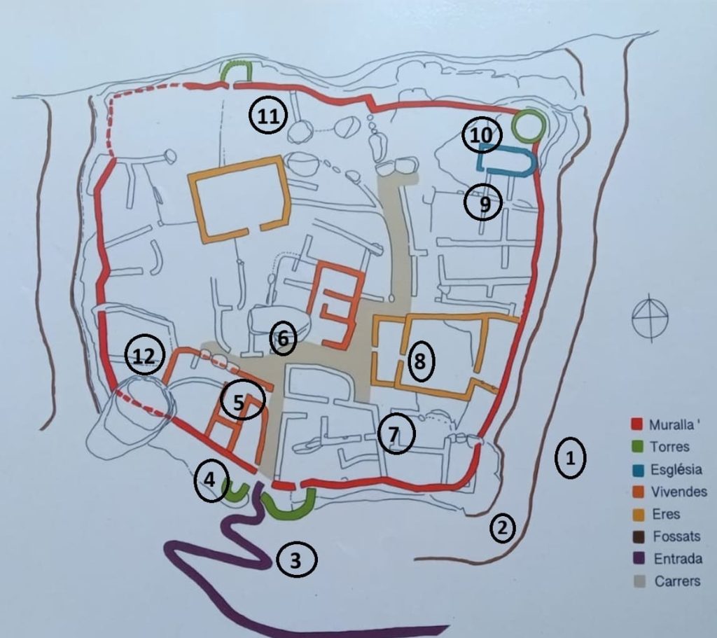
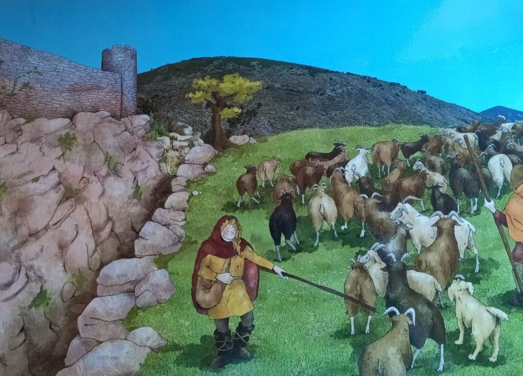
POINT 1: ESPLANADE / DITCH (MOAT)
The construction of ditches in high-mountain fortifications presented monumental challenges due to the steep topography and the hardness of the terrain, which was typically dominated by bedrock. Unlike lowland castles, where soft earth allowed for the digging of trenches, mountain ditches were dry and required a massive amount of labor to chip away and fracture the stone using chisels, wet wooden wedges (which expanded to break the rock), and fire to weaken the geological strata.
The main purpose of these ditches was to artificially alter the terrain to neutralize the advantages of the slope. They were excavated at very specific points, often taking advantage of natural mountain faults, especially on the cols or ridges where the relief ascended toward the fortress. In this way, they cut off the only accessible path for the enemy, preventing the approach of siege engines such as battering rams or mobile towers, which were impossible to deploy on sheer, vertical cut surfaces.
Furthermore, the material extracted from the excavation was not wasted: the stone blocks were used to build the adjacent walls and, in this case, the houses as well, optimizing logistical effort. Their great depth and vertical rock walls turned the ditch into an insurmountable trap, making attackers an easy target for the defenders.
POINT 2: BAUMA (ROCK SHELTER)
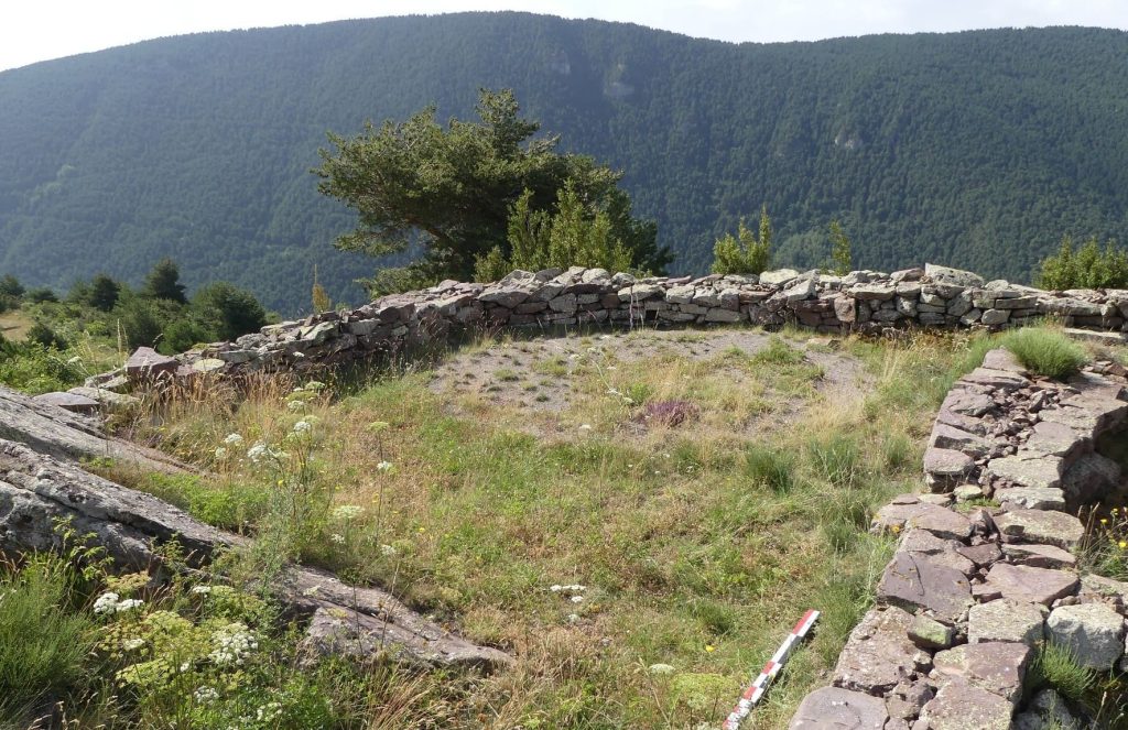
At this point, looking at the two large rocks beneath the medieval wall, you can clearly identify a bauma (cave or shelter) that was used during the prehistoric period. Just above this spot, inside the walled enclosure, the flint piece was discovered. Prehistory in the Catalan Pyrenees demonstrates that the mountain range was not a natural barrier, but rather a living space, intensely inhabited and exploited. Since the Paleolithic, Neanderthal communities and earlier hominids traversed the pre-Pyrenean valleys. During the Upper Paleolithic and the Mesolithic, the lifestyle was nomadic and predatory, centered on hunting large mammals and seasonal gathering. Human groups utilized the network of caves as temporary shelters and workshops to manufacture lithic tools.
The great revolution arrived with the Neolithic and the Bronze Age. The implementation of agriculture and transhumant livestock farming allowed for sedentarization and a progressive conquest of the high mountains. Discoveries like Cave 338 (Queralbs, Ripollès), located at an altitude of 2,235 meters, have overturned the traditional view of these spaces: more than 5,000 years ago, resources like malachite were already being extracted for copper production. Thus, the utilization of Alpine flint, high-altitude pastures, and early mining consolidated a complex society.
POINT 3: PATH TO THE VILLAGE
The path you are currently following was not the main access to the deserted village; remember that there was an excavated ditch. The path originated from the bottom of the valley on the southern face, where the main communication route between the counties of Urgell and Pallars was located. It ran up a steep zigzag incline to the mysterious large stone, before making a final turn to the right, passing beneath the wall to the entrance gate.
Access points to medieval fortifications were meticulously designed to slow down attackers and expose them to defensive action, turning the entrance into the most dangerous point of a siege. The most widely used tactic was the bent or zigzag access. This design prevented the straight-line use of battering rams to break down gates and forced attackers to turn sideways. Since most soldiers were right-handed and carried their shields on their left arms, this forced turn left their right flanks completely unprotected against projectiles launched from the walls.
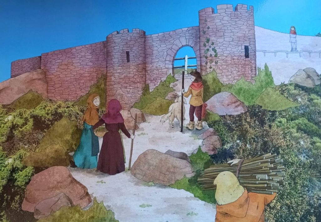
POINT 4: ENTRANCE TO THE VILLAGE
On the midday (southern) side of the enclosed perimeter, and perfectly centered in the wall, opens what currently appears to be the only entrance to the enclosure. This leads to a central street that organizes the layout of the village. This entrance was just over a meter and a half wide and seems to have been flanked on each side by two advanced structures that functioned as potential buttresses or protective towers. These constructions are currently highly disfigured and covered in vegetation.
This space has not yet been fully excavated, so we do not know its external characteristics, potential defensive structures, or even the presence of small ditches or trenches. From the entrance portal, one accessed the interior of the village, which was organized around a main street with an irregular layout that ran longitudinally through the entire built enclosure from south to north, making a few turns. The excavation of a portion of this street has confirmed the absence of paving, forming an irregular floor that largely took advantage of the natural rocky ground.
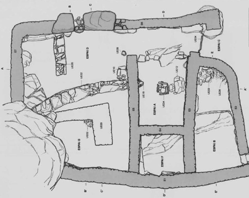
POINT 5: FIRST HOUSE
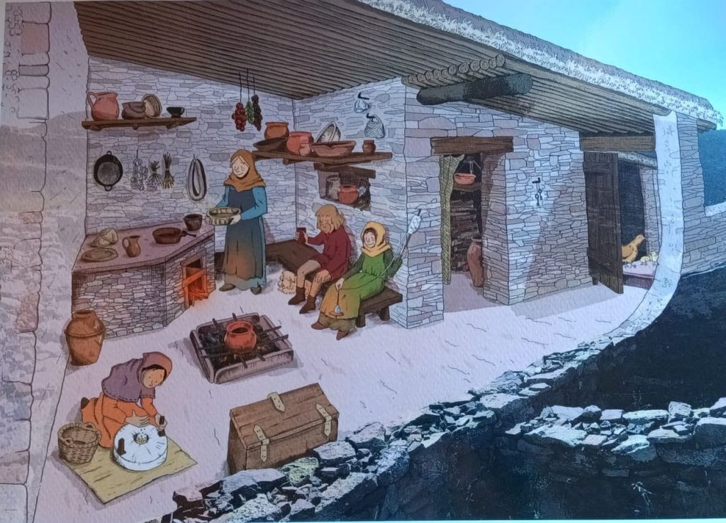
The houses feature an irregular rectangular layout, open to the street, with a simple distribution of three or four rooms: a potential corral for small livestock next to the entrance door (which may have independent access); an interior room used as a storeroom, perhaps for firewood and food; and at the back or center of the building, the main room where the hearth (the fireplace) is located. In both studied cases, the hearth is always central and constructed with stone slabs on the sides and floor. In one instance, a small bread oven is documented, which may be built into a corner bench. Family life was concentrated in this hearth room, and privacy was completely shared by the entire group.
These houses are built with dry-stone walls bound with mud and gravel on the inside. Minimally prepared pavements are found only in the main rooms and consist of stamped and hardened clay of minimal thickness. Likewise, the existence of a type of roof made of flat slabs, bound and covered with clay and branches, and supported by single-slope beams is confirmed. Across the entire settlement area of the village, both in excavated and unexcavated parts, no tile fragments have been found. As a hypothesis, an estimated number of 7 to 10 houses has been calculated. The deposition and dispersion characteristics of the archaeological material found in the abandonment layers of the rooms indicate an intentional departure from the dwellings.
POINT 6: SECOND HOUSE
This is a house with a rectangular layout featuring four distinct spaces.
Space C: Identified as the main room, rectangular in layout, with an entrance opening on the southwest side that connects to the circulation corridor.
Space A: Corresponds to the large square entrance hall, featuring a wide door with a monolithic stone threshold located in its southwest corner, right next to a large block of natural rock. In one of the perimeter walls of this space, a small niche was identified, inside of which an earthenware alcuza (oil jar) was found, showing an oxidized firing and an external honey-colored glaze. No type of pavement or special floor preparation was detected in this space, suggesting it functioned as a small corral, a space for small animals, or perhaps a storeroom.
Space B: Corresponds to a small central room that opens onto a corridor or circulation space. It features a doorway with a threshold made of a flat-laid slab.
POINT 7: FLINT DISCOVERY
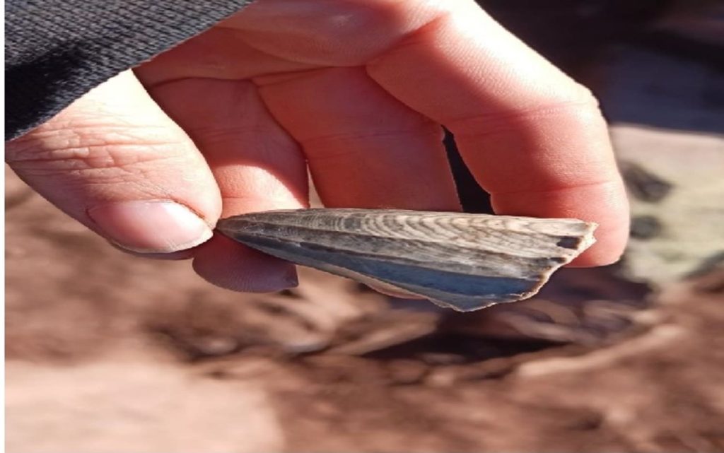
A highly important point for the chronology of the site; highlighted here is the recovery of a flint laminar core. This is not the first time that prehistoric materials have been documented out of context at this site, hinting at an occupation of the hill prior to the medieval village preserved today. However, this particular core stands out because it likely dates to the Neolithic period or even the late Paleolithic. Until now, the prehistoric remains recovered at this site dated to the Middle-Late Bronze Age; therefore, if the chronology of this core is confirmed, the occupation of the hill would date back approximately two thousand years earlier than previously thought.
POINT 8: CORRAL (FARMYARD)
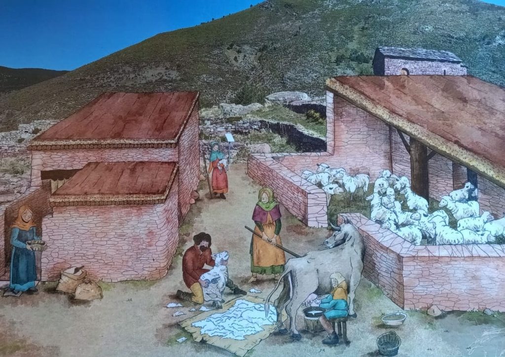
In the interior of the village and amidst the houses, at least two probable farmyards are located, surely intended for communal use to keep the flocks at the end of the day. These corrals are rectangular in layout, built with dry-stone walls, and are of considerable size. This specific corral shows a more complex structure, featuring an anteroom and a second room at the back.
The large presence of archaeological material linked to the sheepherding, focusing, to the production and spinning of wool, such as shearing scissors and various spindle whorls for spinning—along with the existence of the two large pins inside the village, point to clear livestock farming activity in the settlement. This was a dominant activity in Pyrenean communities, especially sheep farming, without disregarding agriculture. It must be taken into consideration that the site stands next to one of the oldest livestock trails in the Pyrenees.
POINT 9: CHURCH
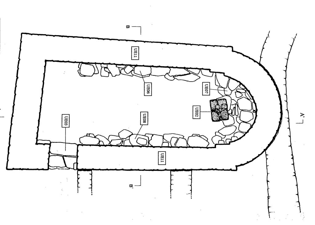
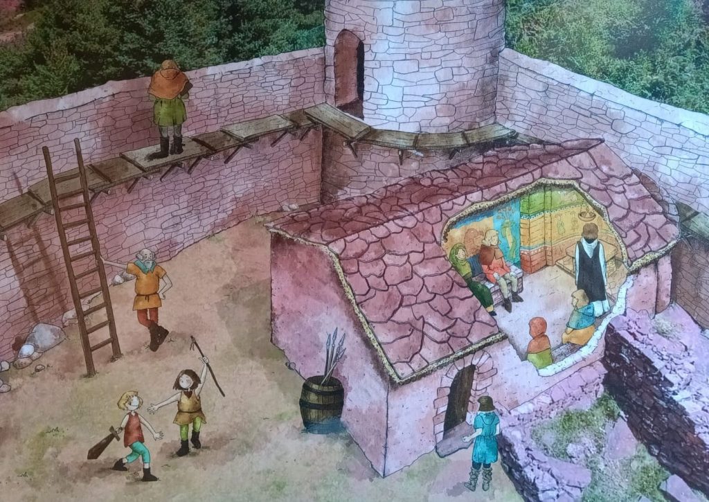
This is the only reconstructed building in the entire site and contains construction elements characteristic of other temples in this Pyrenean area: small rectangular naves with a semicircular apse, with the door opening on the midday (southern) wall, typically dated between the 11th and 12th centuries. Thus, regarding the construction of the church, its marginal position and its overlapping of pre-existing structures indicate a late installation within the village’s urban planning and layout, even post-dating the annexed tower.
Inside the nave, two benches supported by the side walls were found. The uniqueness of these two longitudinal stone benches on the side walls stands out, which may indicate that the enclosure was also used for social functions. They were made of stones and slabs mixed with earth. This space is also where the rectangular support base for the altar table stands. In this layer, a French coin was found—a double tournois of Philip IV (1285-1314)—along with a small bronze crucible lamp with small holes along the rim for hanging. Furthermore, right in front of the church entrance door and beneath a large slab, an iron door key was discovered.
POINT 10: TOWER
In the most dominant sector of the settlement, located at the northeastern end and next to the small church, a circular tower was built, which broke and cut off the stonework of the corner of the preceding wall. Its primary function would have been that of a watchtower, as its location provides an unbeatable visual command that allows for the control of the entire valley; however, it is worth noting that it was built after the construction of the village and its walled perimeter. This type of circular tower, with numerous examples scattered throughout the region, has been dated to around the 10th and 11th centuries.
POINT 11: TOWER AND NEW EXCAVATION
Appearing here is what could be the fourth tower of the complex, also semicircular and built after the construction of the wall. It is possible that defensive needs increased over time, depending on the conflicts inherent to the area. We also find an excavation carried out during the latest works in October 2025; we have not had enough time to identify and confirm what it is, but excavations were conducted here with the intention of finding cisterns or wells that the residents used to store water, whether rainwater or water brought from the ravine on the northern side of the deserted village.
POINT 12: LARGE STONE
Remains of an ancient bauma (rock shelter), which even features a small stone wall on the north side to protect against the cold wind. Many remains of broken pottery, bones, and other refuse from the period were also found here; it must have been among the first structures to be abandoned.
Although the shape of the stone gives free rein to the imagination, no conclusions have been drawn to suggest it was a potential totem or sacred stone; each visitor forms their own opinion.
What we do have a record of is an ancient, large sandstone slab of anthropomorphic shape, 2 meters high and 40 cm thick, which was located right at the Port del Cantó (see photo). Unfortunately, it could not be studied because during the construction of the road, some reckless individuals used leftover dynamite to blow it up, unaware of all the knowledge that was lost.
Bibliography / Drawings / Photographs
ROIG DEULOFEU, Albert – ROIG BUXO, Jordi (1998). Memòria de la intervenció arqueològica al poblat medieval de Sta. Creu de Llagunes (Soriguera, Pallars Sobirà), campanya agost 1994. Barcelona, març de 1998.
ROIG BUXO, Jordi (1999). Memòria de la intervenció arqueològica al poblat medieval de Sta. Creu de Llagunes (Soriguera, Pallars Sobirà), campanya agost 1996. Barcelona Gener de 1999.
VIDAL ALCARAZ, Ariadna (2024) Memòria de la intervenció arqueològica al despoblat de Santa Creu de Llagunes (Soriguera, Pallars Sobirà). Manresa, gener de 2024.
VIDAL ALCARAZ, Ariadna (2024) Informe preliminar de la intervenció arqueològica al despoblat de Santa Creu De Llagunes (Soriguera, Pallars Sobirà). Manresa, desembre de 2024.
HURTADO, Mar
GAAM, Grup d’Arqueologia de l’Alta Muntanya